
Public consultations about the proposed Icefields Trail project largely overshadowed Jasper National Park’s annual public forum, March 14.
Hosted by Parks Canada, it was the first public consultation about the proposed bike trail since details emerged last summer that Parks intended to build a paved trail from Jasper to the Columbia Icefield.
The biggest concerns brought up during the public meeting included questions about the park’s ecological integrity, cyclists’ safety and the value of public consultations.
Several residents questioned whether public consultations have any real impact given the last time consultations were held Parks Canada approved the Glacier Skywalk despite strong opposition.
“It’s really important to Parks Canada to collect as broad and as accurate feedback as we can from the public,” said Delia Siivola, program manager for indigenous and public consultation and engagement with Parks Canada.
“I can assure you the feedback we’re hearing is not going to be dismissed.”
When asked point-blank whether public consultations ever stop a project she conceded only if the issues can’t be mitigated.
“Identifying significant adverse affects that can’t be mitigated by changing the design are grounds for deciding not to move forward on the project.”
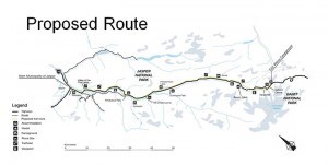
The controversial project envisions building a paved bike trail from Jasper to Wilcox Campground, near the Columbia Icefield.
The majority of the 109-kilometre trail will parallel Highway 93 and use existing trails, portions of the old road, and existing bridges where possible.
Siivola told the audience that the proposed route was chosen to ensure users feel comfortable while enjoying nature, to maximize use of existing infrastructure, to minimize the effects on natural and cultural resources, to connect day use areas, viewpoints and campgrounds and to minimize the number of crossings.
“The trail would start in Jasper and follow Hazel Avenue to Highway 93A and join the Icefield Parkway at Alpine Village. It follows the east side of the Icefields Parkway for the majority of the route,” explained Siivola.
She said the proposed route will cross the highway at least four times, such as from Athabasca Falls to the Mt. Christie picnic area and again at Tangle Hill. The proposed plan will also include additional crossings for people who want to cross the highway to get to a viewpoint or a campground.
According to a 17-page document found online, 95 per cent of the trail will remain within an area zoned for outdoor recreation that extends 100 metres on both sides of the highway.
However, the proposed bike trail will deviate from the zoned area near Beauty Flats following the old paved road for about seven kilometres to Tangle Hill.
“We’re not proposing to use the old road everywhere that it exists, the idea is using it in places where it would reduce potential human-wildlife conflict, perhaps to avoid unstable terrain that exists along the highway and to improve the visitor experience.”
According to the proposed layout, the paved trail will be three metres wide and remain between 10-20 metres away from the edge of the road. The trail will also be built for speeds up to 30 km/h and include 40-metre sight lines. It is expected to be completed by March 2019.
As part of the public consultation process, a senior wildlife biologist with Golder Associates was on hand to discuss the detailed impact analysis process, also known as an environmental assessment.
“The Canadian Environmental Assessment requires that Parks Canada ensures that projects on its land do not cause significant adverse affects,” said Martin Jalkotzy, the princial wildlife biologist carrying out the detailed impact analysis for Golder Associates.
“That process is structured, it’s rigorous, it’s transparent and it’s independent.”
During his presentation he briefly touched on his company’s priorities, including identifying the cumulative effects of the proposed bike path, potential mitigation measures and follow-up monitoring.
So far his company has identified several environmental concerns along the proposed route, including the impact on Whitebark Pine, listed as an endangered species.
“The alignment will be changed to ensure that there aren’t impacts to the Whitebark Pine,” said Jalkotzy.
Other environmental concerns include the impact the bike path could have on species at risk, such as woodland caribou and the common nighthawk, considered threatened under the Species At Risk Act. He also mentioned concerns about aquatic life, such as the bull trout, which is a species of special concern.
“The charismatic mega-fauna that a lot of people come to see in the park will be part of the assessment as well.”
His company has also identified 84 archeological sites along the proposed route, including nine new pre-contact sites that they weren’t aware of before.
“The pre-contact sites were campsites and flintknapping sites, places where you can see where they were making spear points or arrow points,” explained Jalkotzy.
To mitigate some of the environment and archeological concerns he said the plan and design of the proposed route would have to avoid sensitive areas. He also said the design will need to include clear-span bridges instead of culverts to cross-streams.
“If you’re doing a clear-span well you can actually completely eliminate any potential affects on water resources,” said Jalkotzy.
During construction he said work would be carried out in a timely manner to avoid sensitive mating and breeding periods, avoid spawning sites and include site reclamation.
If the project is approved, he said his company would continue to monitor the situation to verify that the mitigation techniques are working. The monitoring would also help verify the predictions of the impact assessment.
“An impact assessment is a prediction of the kind of effects that a project will have,” said Jalkotzy. “Typically the monitoring occurs in places where there is greater uncertainty about the actual potential effect.”
Over the next six weeks Parks Canada will be consulting with indigenous stakeholders as well as the public before drafting the direct impact analysis. Public consultations will also be held in Edmonton, Calgary and Banff. Public feedback closes April 24.
From mid-July to mid-August, the draft version of the direct impact analysis will be available for review and by September a decision will be made.
The Liberal government unexpectedly announced the project in March 2016, when it earmarked $65.9 million in the federal budget.
In June, five environmental groups voiced their opposition to the project citing a lack of public input. The groups said they feared a paved trail would damage critical habitat for endangered species, such as grizzly bears and woodland caribou.
Six months later, in January, the estimated price tag for the project jumped to $86.4 million. Parks Canada said it would cover the addition $20.5 million from its infrastructure investment program.
Following that announcement, the Canadian Parks and Wilderness Society (CPAWS) called on Catherine McKenna, the minister of environment and climate change, to reject the project.
The proposed trail could eventually be extended to Lake Louise, however no decisions have been made.
Paul Clarke
[email protected]