
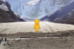
 The Athabasca Glacier is rapidly melting, decreasing at a rate of five metres a year.
But don’t fret, thanks to Google Maps it’s frozen in time, with a “street” view tour that will allow us to appreciate it even after it’s gone.
The 360-degree photos were taken last summer and went live last week, allowing tech savvy folks to virtually “walk” the trail to the toe of the glacier with a click of a mouse.
Following the path, whether in reality or through a fancy device, provides a view of the glacier’s rapid decline, as the viewer moves along a gravel trail that was formerly covered by ice. Along the way, milestones are marked, indicating the location of the glacier’s toe at any given time and showing the speed with which it has receded.
The markers date back as early as 1890 and show a recession of more than 1.5 kilometres.
The experience is startling, no matter how you view it. And although—in a way—it’s seems ridiculous that anyone would want to virtually visit the glacier, rather than prying their eyes off their computer screen and making the trek down the Icefields Parkway to see it for themselves, there is a benefit to having the tour online.
The map is now a resource, showing us—in panoramic views—where the glacier sat in 2014 and providing another way to gauge its retreat.
But, most importantly, it’s providing an opportunity for people around the world to learn about the loss of our glaciers. It’s a starting point, a way of engaging a huge audience in this important issue.
Perhaps after “walking” the trail, it will inspire those folks to dig a little deeper to find the environmental implications of the planet’s rapidly receding glaciers and they will gain a new understanding and appreciation for these massive slabs of ice.
So, ridiculous or not, we’re calling this one a win for the Internet.
That, however, doesn’t mean we condone experiencing everything through a screen.
So go on, get outside. Take a hike!